 Airport
 Island
 Landscape
Venice: Doge's Palace Reserved Entry Ticket
43.382 reviews
Buy now
From 35,00€ per person
 Attivita
 Attraction
 Citta
Citta Village
The interactive map of Veneto, which you will find on this page, presents all the main tourist resorts and points of interest in the region. You can therefore view cities of art, ski resorts, beaches, coastal villages and other locations, as well as places of interest such as airports.
We propose the physical map of Veneto, with the main locations in the region. Click on the image to see it enlarged or click here to download the PDF.
Veneto is located in the north-eastern part of Italy and is the central region of the macro-area known as Triveneto or Tre Venezie (which also includes Trentino-Alto Adige and Friuli-Venezia Giulia).
It is among the largest regions of continental Italy and one of the most densely populated; exceptions are some mountainous areas and the Po delta area where the number of inhabitants is much lower.
Approximately 50 % of the Veneto region is flat, corresponding to the central-southern part of the region; the monotonous Veneto plain rises gently in the areas of the Euganean Hills, south of Padua, and the Berici Hills between Verona and Vicenza.
In the central part of the region, the hills give way to low mountain ranges that gradually rise until they reach peaks of over 3,000 metres in the northern belt of the Dolomites.
From an administrative point of view, Veneto has 6 provinces. From south to north we find: Rovigo, Padua, Verona, Vicenza, Treviso and Belluno. The province of Venice became a metropolitan city in 2015.
 Hotel
Hotel  Budget accommodations
  Apartments
  Family Hotel
 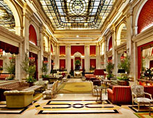 Luxury Hotel
  Resorts